

By Janine Thomson - REALTOR | Pemberton Holmes
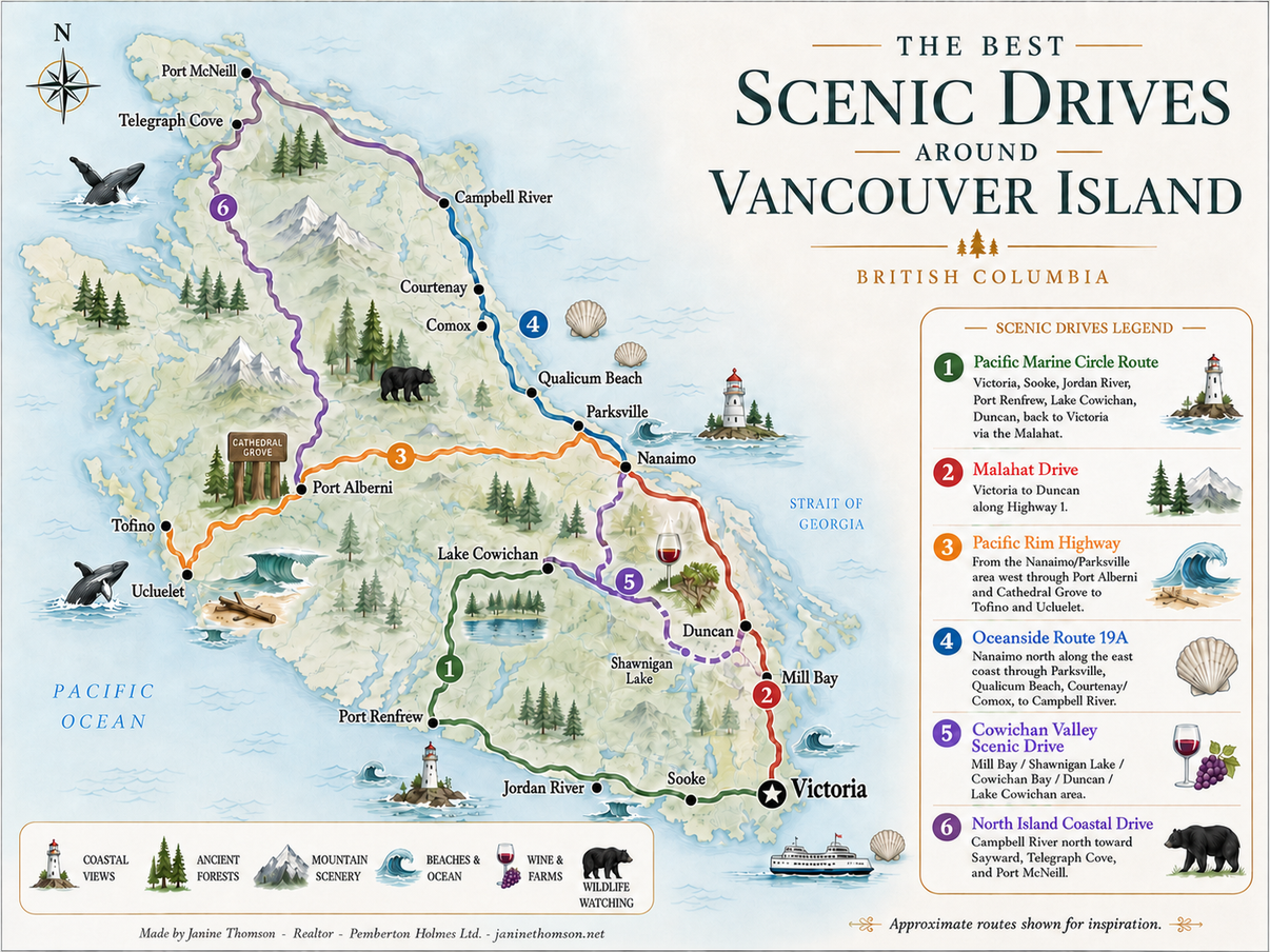
Vancouver Island is made for road trips. Its highways and quieter country roads pass through old-growth forests, coastal communities, mountain valleys, agricultural land and stretches of shoreline that feel wonderfully removed from city life. One drive may follow the open waters of the Strait of Georgia, while another disappears into dense rainforest before arriving at a beach facing the full force of the Pacific Ocean.
The six scenic drives shown on the accompanying map offer very different ways to experience the Island. Some are complete loops that can begin and end in Victoria. Others are point-to-point journeys connecting major communities with smaller villages, beaches, parks and roadside viewpoints. Together, they reveal how varied Vancouver Island can be, from the vineyards and farms of the Cowichan Valley to the rugged wilderness north of Campbell River.Although several of these routes can technically be driven in one day, the best scenic drives are rarely about reaching the destination as quickly as possible. A good Vancouver Island road trip leaves time for forest walks, beach stops, photographs, local cafés and unexpected detours. Distances can also be deceptive. Mountainous terrain, winding roads, traffic, construction and wildlife can all add time to a journey.
The map is intended as an inspirational overview rather than a turn-by-turn navigation guide. Before leaving, check current highway conditions, closures, construction notices and webcams through DriveBC. This is especially important on Highway 4, the Pacific Marine Circle Route and the roads leading into northern Vancouver Island. Download the scenic drives map
Main communities: Sooke, Jordan River, Port Renfrew, Lake Cowichan and Duncan
Ending point: Victoria
1. Pacific Marine Circle Route
Starting point: VictoriaMain communities: Sooke, Jordan River, Port Renfrew, Lake Cowichan and Duncan
Ending point: Victoria
The Pacific Marine Circle Route is one of the most complete road-trip experiences on southern Vancouver Island. It begins in Victoria, follows the southern coastline through Sooke and Port Renfrew, turns inland toward Lake Cowichan and Duncan, and then returns to Victoria over the Malahat.The full circuit is approximately 289 kilometres. It can be completed in a long day, but two to four days provides a much better opportunity to explore the beaches, forests, lakes and small communities along the way. The route is fully paved, although parts of it are narrow, winding and remote.
Beginning in Victoria
Starting in Victoria gives you an opportunity to enjoy the contrast between an urban waterfront and the wilderness that gradually appears as you travel west. From downtown, follow the route toward Langford and then continue along Highway 14 toward Sooke.The first portion of the drive passes through established West Shore communities before the scenery begins to open into forest, farmland and glimpses of the coastline. Those with extra time may choose to detour through Metchosin or toward East Sooke, where the landscape feels surprisingly rural despite being relatively close to Victoria.
Sooke is the largest service centre before the route continues into more isolated territory. It is an excellent place to fill the fuel tank, purchase food and confirm that you have downloaded any maps or directions you may need. Services become more limited beyond Sooke, and cellular reception can disappear for substantial portions of the western route.
Sooke and the Juan de Fuca coast
Sooke is surrounded by forest, harbour views and access to outdoor recreation. One worthwhile detour is Sooke Potholes Provincial Park, known for its river canyon, forest trails and naturally carved rock pools. The conditions around the river change considerably with the seasons, so visitors should remain cautious near fast-moving water.Continuing west from Sooke, Highway 14 begins to feel much more like a remote coastal road. Forest crowds the roadside, the highway becomes narrower and the ocean appears through openings in the trees. French Beach Provincial Park is one of the first major shoreline stops. It is located approximately 20 kilometres west of Sooke and offers access to the Strait of Juan de Fuca. Farther west, the route passes beaches and trailheads associated with Juan de Fuca Provincial Park. The park protects a dramatic section of coastline with views of surf, marine wildlife and forested headlands. China Beach, Mystic Beach and Botanical Beach are among the best-known destinations in the area, although each requires a different amount of time and physical effort. Jordan River is a natural place to pause. This small coastal community is known for its ocean views and surf culture. On a clear day, you can look across the Strait of Juan de Fuca toward the mountains of Washington State. The shoreline is rugged rather than manicured, and the changing weather is part of the experience.
The section between Jordan River and Port Renfrew is one of the most memorable parts of the drive. It is also a section where drivers should slow down and remain attentive. Expect curves, changing road surfaces, limited passing opportunities and occasional single-lane bridges.
Arriving in Port Renfrew
Port Renfrew feels like the end of the road, even though the Pacific Marine Circle Route continues inland. The community is surrounded by rainforest, rivers and a wild coastal environment. It has long been associated with fishing, hiking and access to some of southern Vancouver Island’s most impressive natural areas.Botanical Beach is one of the principal attractions. At low tide, visitors may be able to observe tidal pools and exposed rock formations along the shoreline. Tide times and ocean conditions should always be checked before visiting, as the area is exposed to powerful waves and rapidly changing water levels.
Port Renfrew is also known for its proximity to exceptionally large trees. The broader region contains old-growth western red cedar, Douglas fir and Sitka spruce. Some forest destinations are reached by roads that may be rougher than the main highway, so conditions should be confirmed before leaving the paved route. Tourism Vancouver Island identifies Botanical Beach and the region’s giant trees as two of Port Renfrew’s defining attractions.
Turning inland toward Lake Cowichan
After Port Renfrew, the drive leaves the open coastline and follows Pacific Marine Road toward Lake Cowichan. This is a dramatic transition. Ocean views give way to river valleys, thick forest and mountainous terrain.Fairy Lake is a popular roadside stop, particularly for the small tree growing from a partially submerged log. Farther along, the Harris Creek Spruce offers another opportunity to appreciate the scale of Vancouver Island’s rainforest.This portion of the route feels isolated. Fuel, food and cellular service may be limited, and drivers should be prepared for wildlife on or near the roadway. It is better to travel during daylight and avoid rushing.
Lake Cowichan marks the return to a larger community. The town sits near the eastern end of Cowichan Lake and provides access to swimming, boating, paddling and riverside recreation. The lake is a major summer destination, and many visitors choose to stay overnight rather than continuing immediately toward Duncan.
Lake Cowichan to Duncan
From Lake Cowichan, follow Highway 18 east toward Duncan. The road travels through a forested valley alongside portions of the Cowichan River corridor. Optional stops may include river viewpoints, trail access and recreation areas, depending on the season.Duncan provides a noticeable change in atmosphere. After the wild coast and interior forest, you arrive in an agricultural valley with farms, markets, vineyards and established communities. Duncan is known for the hand-carved totem poles found throughout its downtown and for its year-round market culture. This is also where the Pacific Marine Circle Route begins to overlap with the Cowichan Valley scenic drive. Travellers with additional time can visit Cowichan Bay, explore local wineries or detour toward Shawnigan Lake and the Kinsol Trestle.
Returning to Victoria over the Malahat
The final leg follows Highway 1 south from Duncan through Cobble Hill and Mill Bay before climbing the Malahat. The broad views over Saanich Inlet provide a fitting conclusion to the trip.Goldstream Provincial Park is the last major natural landmark before returning to Greater Victoria. Located along Highway 1 northwest of Victoria, it contains temperate rainforest, waterfalls and an extensive network of trails. The Pacific Marine Circle Route ultimately ends where it began: in Victoria. By the time you return, you will have experienced open coastline, surf beaches, old-growth forest, mountain roads, freshwater lakes, agricultural valleys and elevated views over the Salish Sea.
This is the most diverse of the six drives and the best choice for travellers wanting one route that captures many of Vancouver Island’s defining landscapes.
Main communities: Langford, Malahat, Mill Bay and Cobble Hill
Ending point: Duncan
2. Malahat Drive
Starting point: VictoriaMain communities: Langford, Malahat, Mill Bay and Cobble Hill
Ending point: Duncan
The Malahat Drive is the most direct scenic journey between Victoria and the Cowichan Valley. It follows Highway 1 north from Victoria, passing through Goldstream Provincial Park before climbing above Finlayson Arm and Saanich Inlet.The drive from Victoria to Duncan is approximately 76 kilometres. Without stops, it can be completed relatively quickly. However, several viewpoints, parks and communities make it worth treating as a half-day or full-day outing.
Leaving Victoria
Begin in Victoria and travel north through Uptown and View Royal toward Langford. The opening section is urban, but the transition into forest happens quickly once you pass the principal West Shore interchanges.Goldstream Provincial Park is the first major scenic area. The highway passes through a steep, forested corridor where tall trees, exposed rock and the Goldstream River create a dramatic entrance to the Malahat.
Visitors can stop at designated park areas to explore the forest on foot. Depending on the trail selected, possible destinations include waterfalls, river scenery and elevated viewpoints. Goldstream is also known for its annual salmon run, although timing and viewing conditions vary.
Climbing the Malahat
After Goldstream, Highway 1 begins its ascent through the Malahat. The road rises above Finlayson Arm, creating views across the water toward forested hills, the Saanich Peninsula and the Gulf Islands.The Malahat has historically served as the main land connection between Greater Victoria and communities to the north. It is an active highway rather than a quiet country road, so drivers should concentrate on traffic while passengers enjoy the views. Use designated turnoffs and attractions rather than stopping along the highway shoulder.
One of the route’s major attractions is the Malahat SkyWalk. Its elevated walkway and spiral tower provide panoramic views of Finlayson Arm, Saanich Inlet, the Saanich Peninsula, the Gulf and San Juan Islands, Mount Baker and the coastal mountains when conditions are clear.
Descending toward Mill Bay
North of the Malahat summit, the road descends toward Bamberton and Mill Bay. Bamberton Provincial Park is located near the north end of the scenic Malahat section and offers access to a beach on Saanich Inlet. Mill Bay is a quiet seaside community with views across the inlet. It is a worthwhile lunch or walking stop, particularly for travellers who would like to leave the highway and experience the shoreline at a slower pace.An alternate return route is available through the small Mill Bay–Brentwood Bay ferry. Rather than continuing to Duncan or returning over the Malahat, travellers can cross Saanich Inlet and explore the Saanich Peninsula. Ferry schedules and vehicle capacity should be checked in advance.
Continuing into the Cowichan Valley
Beyond Mill Bay, the landscape changes from steep mountain terrain to rolling farmland. Cobble Hill is surrounded by agricultural properties, orchards and vineyards, signalling your arrival in the Cowichan Valley.The route ends in Duncan, where you can explore the downtown core, visit local businesses or continue toward Cowichan Bay, Lake Cowichan or Nanaimo.
The Malahat Drive is ideal for travellers who want a shorter scenic trip from Victoria. Its appeal lies in the rapid change of scenery: city streets become rainforest, the highway climbs above a narrow ocean inlet, and the northern descent opens into one of Vancouver Island’s most productive agricultural regions.
Main communities: Parksville, Qualicum Beach, Port Alberni, Ucluelet and Tofino
Ending point: Tofino, with Ucluelet as an important southern branch and alternate destination
3. Pacific Rim Highway
Starting point: Nanaimo, with the westbound portion beginning near Parksville and Qualicum BeachMain communities: Parksville, Qualicum Beach, Port Alberni, Ucluelet and Tofino
Ending point: Tofino, with Ucluelet as an important southern branch and alternate destination
The drive to Vancouver Island’s Pacific coast is one of its most iconic road trips. The map begins the route in the Nanaimo and Parksville area before directing travellers west through Port Alberni, Cathedral Grove and the Island’s mountainous interior.
The western section follows Highway 4. Travellers arriving from Nanaimo first drive north toward Parksville and Qualicum Beach before turning west. From there, the road crosses the Island and eventually divides near the Pacific coast, with one direction leading south to Ucluelet and the other continuing north to Tofino.
Nanaimo to Parksville and Qualicum Beach
Beginning in Nanaimo allows travellers to enjoy the city’s waterfront before heading north. Nanaimo is an important ferry gateway, making it a convenient starting point for visitors arriving from the Lower Mainland.The first part of the drive follows the east side of Vancouver Island. Depending on your schedule, you may stop in Parksville for its broad beach, waterfront park and resort area.
Rathtrevor Beach Provincial Park, located just south of Parksville beside Highway 19A, is known for its extensive shoreline and shallow tidal flats. At low tide, the water can retreat a considerable distance, creating a wide area for walking and beachcombing. Qualicum Beach offers another attractive shoreline stop before the route turns inland. This is a good place to purchase food and fuel, particularly when travelling during busy summer periods.
Coombs and the inland transition
A detour through Coombs adds one of Vancouver Island’s best-known roadside attractions: the Old Country Market and its famous goats on the roof. The surrounding area has a relaxed rural atmosphere, with small shops, farms and forested roads.As the route continues west, the coastal scenery disappears and the landscape becomes mountainous. This transition is part of what makes the journey memorable. In a relatively short distance, you move from the calm waters of the Island’s eastern side into an interior environment shaped by lakes, rivers and old forest.
Cathedral Grove
MacMillan Provincial Park, commonly known as Cathedral Grove, is located directly along Highway 4 between Qualicum Beach and Port Alberni. The park protects a remarkable stand of old-growth Douglas fir and western red cedar. Some of the trees are several centuries old, and short walking trails lead through the forest on both sides of the highway. Cathedral Grove is one of the most popular stops on central Vancouver Island. Parking is limited, and the highway can be extremely busy. Drivers should only park where permitted and should take particular care when crossing the road.The forest experience is very different from simply viewing trees through a car window. Inside the grove, the scale of the trunks, the filtered light and the thick understory create the quiet, enclosed atmosphere associated with Vancouver Island’s temperate rainforest.
Cameron Lake and Port Alberni
After Cathedral Grove, the road follows Cameron Lake and climbs through the mountains before descending into the Alberni Valley.Port Alberni is located at the head of Alberni Inlet. It has a long relationship with forestry, fishing and marine transportation. The community is a practical place to stop for food and fuel, but it also deserves time of its own. Waterfront areas, museums and access to nearby lakes and rivers offer plenty to explore.
Tourism Vancouver Island recommends attractions such as the Alberni Valley Museum and Stamp River Provincial Park. The latter is known for river scenery, trails and seasonal salmon activity. Before leaving Port Alberni, confirm that you have sufficient fuel. The next section is long, winding and comparatively remote. Cellular reception can be unreliable or unavailable along portions of the highway.
Port Alberni to the Pacific coast
West of Port Alberni, Highway 4 enters one of Vancouver Island’s most dramatic road corridors. The route passes Sproat Lake before moving through mountain passes, rainforest and river valleys.This is not a highway to rush. There are sharp curves, elevation changes and limited passing opportunities. Weather can also vary considerably between Port Alberni and the coast.Along the way, travellers may see steep forested slopes, exposed rock, rushing water and glimpses of Kennedy Lake. The landscape begins to feel distinctly coastal again as the highway approaches the junction for Ucluelet and Tofino.
The sense of arrival is gradual. The forest becomes denser and wetter, the air changes, and signs begin directing travellers toward Pacific Rim National Park Reserve and the two west-coast communities.
Ucluelet
At the main junction, turn south to visit Ucluelet. The community occupies a rugged peninsula surrounded by ocean, inlets and rocky shoreline.The Wild Pacific Trail is one of Ucluelet’s signature experiences. Its coastal sections provide views of offshore rocks, rainforest and open water. During storm season, waves can be especially dramatic, although visitors should remain well back from exposed shoreline edges.
Ucluelet also has a working harbour and a more compact, residential feeling than Tofino. It is an excellent place to stay overnight and can serve as a quieter base for exploring the Pacific Rim region. Tourism Vancouver Island highlights the Wild Pacific Trail and the community’s collect-and-release aquarium among its principal attractions.
Ucluelet to Tofino
Return to the junction and travel north toward Tofino. This portion of the highway passes through Pacific Rim National Park Reserve and provides access to some of Vancouver Island’s most celebrated beaches.Wickaninnish Beach, Long Beach and other coastal areas reveal the scale of the open Pacific. The shoreline is broad, windswept and framed by dark forest. Surfers, walkers, photographers and storm watchers are drawn to the area throughout the year.The Rainforest Trail offers a contrasting experience, leading visitors beneath a dense canopy of cedar and hemlock. Boardwalk sections make it possible to explore the rainforest without travelling far from the highway.
The road ends in Tofino, a small community overlooking Clayoquot Sound. Tofino combines a working harbour, Indigenous culture, outdoor adventure, galleries, accommodation and a highly regarded food scene. Old-growth rainforest, open ocean and sheltered inlets all meet within a relatively small area. The Pacific Rim Highway is best treated as an overnight journey rather than a hurried day trip. Its most memorable moments occur when you step out of the vehicle: walking through Cathedral Grove, pausing beside a lake, following a rainforest boardwalk or standing on a Pacific beach as waves arrive from thousands of kilometres away.
Main communities: Parksville, Qualicum Beach, Courtenay and Comox
Ending point: Campbell River
4. Oceanside Route 19A
Starting point: NanaimoMain communities: Parksville, Qualicum Beach, Courtenay and Comox
Ending point: Campbell River
The Oceanside Route follows Highway 19A from the Nanaimo area north toward Campbell River. Unlike the faster inland Highway 19, Route 19A remains closer to the eastern shoreline and passes through established seaside communities.
Tourism Vancouver Island identifies Highway 19A as the scenic Oceanside Route connecting Nanaimo with Campbell River. It is the better choice for travellers interested in beaches, small towns and frequent stops rather than the fastest possible journey.
Nanaimo to Parksville
Begin near Nanaimo’s waterfront and travel north. Where possible, choose the older Island Highway and Highway 19A rather than remaining on the inland expressway.The early section passes residential communities, forest and occasional ocean views. The Strait of Georgia lies to the east, with the mountains of the mainland visible on clear days.Parksville is the first major stop. Its long, shallow beach is popular with families, walkers and photographers. During low tide, the exposed shoreline can appear almost endless.
Rathtrevor Beach Provincial Park is located nearby and makes an excellent place for a picnic or longer beach walk. Those staying overnight will find a range of resorts, campgrounds and vacation accommodations throughout the Parksville area.
Parksville to Qualicum Beach
The drive between Parksville and Qualicum Beach is relaxed and scenic. Rather than dramatic cliffs or mountain passes, this section offers calm coastal views, mature neighbourhoods and access to beaches.Qualicum Beach has a walkable village centre set slightly inland from the waterfront. Its shops, cafés and gardens make it a pleasant place to spend several hours.The waterfront road provides views across the Strait of Georgia. Depending on the weather, you may see the Coast Mountains beyond the water or watch marine traffic moving through the strait.The Lighthouse Country communities
North of Qualicum Beach, Highway 19A continues through a series of smaller seaside communities commonly associated with Lighthouse Country.The road passes beaches, forested properties, cottages and rural neighbourhoods. This is a slower stretch of the journey, and its appeal comes from the repeated opportunities to pull into a beach access, local shop or roadside restaurant.Travellers can also detour toward inland parks, caves and trails, although doing so can easily turn the drive into a multi-day itinerary.Fanny Bay and the Comox Valley
As you continue north, the road reaches communities around Fanny Bay and Buckley Bay. This area is closely connected to aquaculture, shellfish and marine industries.The route then enters the Comox Valley, which includes Courtenay, Comox and surrounding agricultural areas. Courtenay has a lively downtown, riverfront walks and access to shops and restaurants. Comox sits beside the water and offers views toward the mountains and Strait of Georgia.
The Comox Valley is an excellent overnight stop because it combines coastal scenery with farms, galleries, trails and access to Mount Washington. The region’s Indigenous art and culture can also be explored through destinations such as the I-Hos Gallery, owned by the K’ómoks First Nation.
Comox Valley to Campbell River
North of Courtenay and Comox, Highway 19A continues through a mixture of forest, shoreline and rural communities.Miracle Beach Provincial Park is situated approximately midway between Courtenay and Campbell River. The park includes an oceanside day-use area and a large forested campground. As you approach Campbell River, the views begin to include the islands and channels of the Discovery Passage region. The marine environment feels more active here, with fishing boats, ferries, cruise ships and working vessels moving through the water.
The drive ends in Campbell River. Discovery Pier and the waterfront are natural places to finish the journey. Campbell River is also the gateway to Strathcona Provincial Park, the Discovery Islands and the northern portion of Vancouver Island.
The Oceanside Route is not the Island’s most dramatic drive, but it may be its most relaxing. Beaches, waterfront communities and services appear regularly, making it particularly suitable for families, leisurely summer travel and visitors who prefer frequent stops over remote wilderness.
Main communities: Shawnigan Lake, Cobble Hill, Cowichan Bay and Duncan
Ending point: Lake Cowichan
5. Cowichan Valley Scenic Drive
Starting point: Mill BayMain communities: Shawnigan Lake, Cobble Hill, Cowichan Bay and Duncan
Ending point: Lake Cowichan
Unlike the Pacific Marine Circle Route or Highway 19A, the Cowichan Valley Scenic Drive is best understood as a flexible regional itinerary rather than one continuously signed highway.
The route illustrated on the map connects several of the Cowichan Valley’s most attractive communities. Beginning in Mill Bay, it explores Shawnigan Lake, Cobble Hill, Cowichan Bay and Duncan before heading west to Lake Cowichan.
This drive is less about dramatic wilderness and more about discovering the Island’s agricultural landscape, vineyards, lakes, heritage sites and small communities.
Mill Bay
Begin in Mill Bay, a quiet seaside community overlooking Saanich Inlet. The waterfront provides views toward the Saanich Peninsula, and local parks offer short walks near the shore.Mill Bay Nature Park has easy trails, beach access and a viewing platform overlooking the water. The area also serves as a connection point for the Mill Bay–Brentwood Bay ferry, which provides a scenic alternate route to the Saanich Peninsula. For this road trip, however, continue inland toward Shawnigan Lake.
Shawnigan Lake
Shawnigan Lake is surrounded by forested hills, residential neighbourhoods and recreation areas. The lake has long been a popular summer destination for swimming, paddling and boating.Shawnigan Village, located near the northern part of the lake, contains cafés, shops and community services. Tourism Cowichan describes the area as a hidden gem bordered by Cobble Hill and Mill Bay, with mountains, West Coast forest, parks and trails surrounding the lake. The roads around Shawnigan Lake are often narrower and more residential than the main highway. Drive carefully and respect private property when looking for lake access.
Kinsol Trestle
One of the region’s most impressive attractions is the Kinsol Trestle, located north of Shawnigan Lake.The restored wooden railway trestle spans the Koksilah River and forms part of the Trans Canada Trail network. It stands approximately 44 metres high and 188 metres long, making it one of the largest wooden trestles of its kind. Viewing platforms and nearby trails provide several perspectives of the structure and river valley. Visiting the trestle requires leaving the main driving route and completing a short walk, but it is one of the best stops in the Cowichan Valley.
Cobble Hill and wine country
Continue toward Cobble Hill, where the landscape becomes increasingly agricultural. Expect rolling fields, orchards, farm stands and vineyards rather than the dense rainforest found on the western side of the Island.The Cowichan Valley is Vancouver Island’s principal wine region. Tourism Cowichan identifies 13 wineries in the region, many of which offer tasting rooms, patios and vineyard views. Wine tasting should be planned responsibly.
A designated driver or organized tour allows everyone to enjoy the region safely. Visitors who do not drink wine will still find plenty of interest in local cideries, farm markets, bakeries and restaurants.
The drive through Cowichan wine country is particularly attractive in late summer and early autumn, when vineyards and farms are at their most active.
Cowichan Bay
From Cobble Hill, continue toward Cowichan Bay. The road descends toward an estuary and waterfront village, with views of Mount Tzouhalem and the surrounding agricultural land.Cowichan Bay has a distinctive maritime atmosphere. Colourful buildings, floating homes, working docks, bakeries, cafés and small shops line the waterfront.
The Cowichan Estuary is both ecologically and culturally significant. Visitors can learn more about the region at the Cowichan Estuary Nature Centre or the Cowichan Bay Maritime Centre. Tourism Cowichan describes the route along Tzouhalem and Cowichan Bay roads as an especially scenic approach, travelling beneath Mount Tzouhalem and alongside the estuary.
Duncan
From Cowichan Bay, continue inland to Duncan. The downtown core is compact and known for its collection of totem poles, local businesses and market atmosphere.Duncan makes a convenient lunch stop and provides access to other parts of the Cowichan Valley. It also marks the transition from the southern agricultural portion of the route to the forested drive west toward Lake Cowichan.
Duncan to Lake Cowichan
Leave Duncan and follow Highway 18 west. The approximately 26-kilometre journey toward Lake Cowichan passes through forest and follows the broader Cowichan River corridor. Lake Cowichan is a natural place to end the drive. The town sits where the Cowichan River leaves the lake, creating opportunities for swimming, paddling, riverside walking and other warm-weather activities.Those with more time can continue west along the lake toward Mesachie Lake, Honeymoon Bay or Youbou. Some roads around the lake are unpaved, so confirm conditions before attempting a complete circuit. The Cowichan Valley drive is ideal for travellers who appreciate food, agriculture, lakes and local communities. It offers a gentler form of sightseeing than the Island’s remote coastal routes, but it is no less rewarding.
Main communities: Sayward, Woss, Telegraph Cove and Port McNeill
Ending point: Port McNeill
6. North Island Coastal Drive
Starting point: Campbell RiverMain communities: Sayward, Woss, Telegraph Cove and Port McNeill
Ending point: Port McNeill
The North Island Coastal Drive begins in Campbell River and follows Highway 19 into the more remote northern half of Vancouver Island.Despite the route’s name, much of Highway 19 travels inland through forest rather than directly beside the ocean. The coastal experiences are found in the communities and detours connected to the highway, particularly Sayward, Telegraph Cove, Port McNeill and the shores of the Broughton Strait.
Tourism Vancouver Island describes the journey north as one of the Island’s longest and wildest road-trip routes. Beyond Campbell River, the highway enters dense forest, cellular reception becomes inconsistent and communities are farther apart.
Campbell River
Begin at Campbell River’s waterfront. Before heading north, walk along Discovery Pier or visit the shoreline overlooking Discovery Passage.Campbell River is an important service centre, so it is the best place to purchase supplies and fill the fuel tank. North of the city, services become less frequent.
Elk Falls Provincial Park is a worthwhile stop before beginning the long drive. Its suspension bridge and waterfall are located a short distance inland from Campbell River. Tourism Vancouver Island identifies Elk Falls and Discovery Pier as two of the community’s principal attractions.
Campbell River to Sayward
Highway 19 turns inland north of Campbell River. The road travels through extensive forest, with mountain views appearing between the trees.The turnoff to Sayward leads east toward a small community near the head of Kelsey Bay. Sayward is surrounded by forest, estuary habitat and mountain scenery. It is also a practical fuel and rest stop.
The North Island is wildlife country. Black bears, Roosevelt elk and deer may appear near roadsides, especially around dawn and dusk. Drivers should remain alert, avoid stopping beside wildlife and never attempt to feed animals.
Sayward to Woss
Returning to Highway 19, continue north toward Woss. This section emphasizes the scale and remoteness of the northern Island. Long stretches of highway pass through forest with relatively few buildings or services.Woss developed as a forestry community. Its heritage includes historic railway equipment and connections to Vancouver Island’s logging history.
The landscape around Woss is mountainous, and the community provides access to lakes, trails and backcountry destinations. Travellers remaining on the main route will still appreciate the dramatic forest and changing elevation.
Nimpkish Valley
North of Woss, the highway travels through the Nimpkish Valley. One of the most scenic sections follows the long edge of Nimpkish Lake.The lake appears between forested slopes and mountains, creating one of the most memorable views on the northern route. Pull over only at designated and safe locations.Weather can change quickly in this area. Fog, heavy rain and winter conditions may affect visibility, while summer travel can bring construction and recreational traffic.
Telegraph Cove
Turn east from Highway 19 toward Telegraph Cove. The road eventually arrives at one of Vancouver Island’s most distinctive small communities.Telegraph Cove is known for its historic boardwalk, colourful waterfront buildings and sheltered harbour. In summer, fishing boats, kayaks and wildlife-viewing vessels operate from the community.The cove is closely associated with whale watching and access to the Broughton Archipelago. Visitors may encounter opportunities to see orcas, humpback whales, dolphins, sea lions and other marine wildlife through licensed tour operators. Sightings are never guaranteed, but the marine environment is one of the major reasons travellers visit the region. Tourism Vancouver Island describes Telegraph Cove as a picturesque maritime village and a significant wildlife-viewing destination. Telegraph Cove is an excellent overnight stop. Remaining after the day visitors leave allows time to walk the boardwalk, watch the harbour and enjoy the quiet of the surrounding forest.
Ending in Port McNeill
Return to Highway 19 and continue north to Port McNeill. The community overlooks Broughton Strait and serves as an important transportation and service centre for northern Vancouver Island.From the waterfront, visitors can see nearby islands and marine traffic. Port McNeill is also a departure point for ferries serving Alert Bay on Cormorant Island and Sointula on Malcolm Island. These side trips can extend the road trip by one or two days.The drive shown on the map ends in Port McNeill, although travellers can continue north to Port Hardy. From Port Hardy, more remote adventures lead toward Cape Scott Provincial Park and the northern coast.Northern Vancouver Island requires more preparation than the routes around Victoria, Nanaimo or Parksville. Tourism Vancouver Island notes that cellular service may be spotty or unavailable and identifies limited fuel availability between communities. Carry water, food, warm clothing and an emergency kit. Download directions in advance, avoid allowing the fuel tank to become too low and plan to complete unfamiliar sections during daylight.
The North Island drive rewards that preparation with solitude, forest, mountain scenery and access to small coastal communities that feel far removed from southern Vancouver Island.
Choosing the Right Vancouver Island Scenic Drive
Each of these six routes offers a different experience.The Pacific Marine Circle Route is the best all-around choice for travellers who want a complete southern Vancouver Island road trip. It combines beaches, rainforest, remote communities, lakes, farmland and elevated ocean views.
The Malahat Drive is ideal for a shorter trip from Victoria. It offers rainforest, mountain driving and panoramic views before arriving in the Cowichan Valley.
The Pacific Rim Highway provides the most dramatic journey from one side of Vancouver Island to the other, ending among rainforest and Pacific beaches in Ucluelet and Tofino.
The Oceanside Route 19A is a relaxed coastal drive suited to travellers who enjoy beach communities, cafés, parks and frequent waterfront stops.
The Cowichan Valley Scenic Drive is the strongest choice for wineries, farms, lakes, heritage attractions and small-community exploration.
The North Island Coastal Drive offers the greatest sense of wilderness, connecting Campbell River with the forests, mountains and marine communities of northern Vancouver Island.
Whichever route you choose, leave room in the itinerary for the unexpected. Some of Vancouver Island’s best road-trip memories are not necessarily found at the major attractions. They may come from a quiet beach discovered beside the highway, a roadside farm stand, a misty forest walk or a viewpoint where the ocean suddenly appears between the trees.
On Vancouver Island, the journey is not simply the distance between one community and another. The road itself is part of the destination.
